

Heart of Appalachia Bicycle & Dual Sport Route

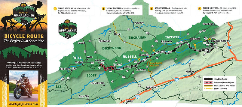
128 Miles | 4 Counties | 11,000+ ft Elevation Gain
This trail is designed for the serious rider. Whether by bicycle or dual sport motorcycle, this challenging route meanders from Burke’s Garden in Tazewell County to St. Paul, delivering an unforgettable backcountry experience. Spanning approximately 128 miles, the ride features over 11,000 feet of elevation gain and loss, with a mix of 21% gravel and 79% paved surfaces. Riders will traverse four counties, winding through the breathtaking Clinch River Valley—a region known for its rugged beauty and remote charm.
Along the route, you’ll pass through Stuart Land and Cattle, one of the largest cattle ranches in the eastern United States. Be prepared to slow down, you may find yourself sharing the road with free-roaming cattle while taking in the peaceful expanse of this working landscape. The journey also leads you into the heart of Beartown Wilderness, where dense forests and unspoiled terrain offer a true sense of isolation. The ride begins—or ends—at Burkes Garden, often called “God’s Thumbprint” due to its unique bowl-shaped formation, frequently mistaken for a dormant volcano.
For those looking to extend the adventure, several camping options are available:
Slates Farm Campground (open May–October), located directly along the Clinch River,
185 Campground Rd, Honaker, VA 24260
Camp Mountventures, 3418 Hidden Acres Rd, St. Paul, VA 24283
Dispersed, DIY camping within Beartown Wilderness
AirBnB options in Burkes Garden and Tazewell County
If you’re considering this ride, come prepared—it’s built for experienced cyclists and riders who
are ready to take on both the physical challenge and the remote terrain.
Recommended apps: Ride with GPS and Google Maps
** In honor of Frank Kilgore - this trail is still in progress and not totally accessible.